




cc.web.local

twitter Facebook linkedin acp

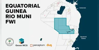
The results of the reprocessing will be out around Q4 2026. (Image source: Geoex MCG)

Following exploration successes from the Zafiro, Asen/Aleng and Ceiba/Okume fields in Equatorial Guinea, the Ministry of Hydrocarbons and Mining Development has now initiated a comprehensive reprocessing campaign in Rio Muni basin, which is anticipated to possess excellent geological promise

A survey over 9,600 sq km of the largely underexplored basin has been launched by Geoex MCG, in partnership with Perceptum and DUG Technology and the Ministry of Hydrocarbons and Mining Development.

Once the results of the reprocessing are out around Q4 2026, interpreters can enjoy the fruits of modern data and full waveform inversion (FWI) workflows, gaining influential insights from enhanced quality images. 

To target areas potentially eligible for exploration development, key down-dip plays within the Miocene and Upper Cretaceous–Paleogene intervals will be put to reprocessing. The L-1 and L-2 wells will be tied for attaining velocity and depth control. 

Equatorial Guinea, including offshore Sao Tome and Principe as per the Jaca well, is known to be rich in reservoir and source sequences, and the reprocessing team will be hunting for the entry points to especially access potential source rock presence in these regions. An in-depth understanding of the tectonic history will help delineate the largely coveted distal petroleum systems which holds the promise of vast volumes. The reprocessing will generate advanced images of high-resolution delineation of aged intervals in the region.

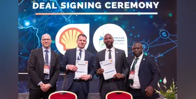
Sierra Leone has been working consistently to attract investment for its upstream sector. (Image source: Invest in African Energy)

Oil major, Shell Exploration Company BV, has secured interests in Sierra Leone with the signing of Reconnaissance Permit Agreement through the Petroleum Directorate of Sierra Leone (PDSL) during the Invest in African Energy 2026 Forum in Paris

Aligning with the country's strategy of derisking frontier acreage, the agreement allows Shell the rights to initiate advanced geological and geophysical studies across offshore G-Blocks that adds up to approximately 20,594 sq kms. The major will conduct seismic data quality control and interpretation, integration of well data, detailed petrophysical analysis, basin modelling, petroleum systems evaluation, identification of structural traps and reservoir fairways, and play-based exploration and prospectivity mapping.

“This agreement with Shell marks a defining moment in Sierra Leone’s journey to responsibly unlock the value of our natural resources. It sends a strong and credible signal to the global investment community… that Sierra Leone is open for business, underpinned by transparency, stability and strong governance,” said President Julius Maada Bio in a statement released by PDSL.

A major of Shell's kind will bring to the region the advantages of high-quality seismic data and advanced subsurface imaging ahead of future licensing rounds. “Signing this agreement...underscores Sierra Leone’s growing visibility on the global energy stage. Securing Shell as a partner is a strong validation of the work we have undertaken to strengthen our geoscience database and regulatory framework," said PDSL director general Foday Mansaray.

Sierra Leone has been working consistently to attract investment for its upstream sector by fostering transparent engagement with global operators. Data, transparency and credible partnerships remain central to the region's upstream ambitions. 


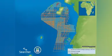
The 7,337 km of data will help de-risk exploration efforts. (Image source: Searcher)

Working closely with the Equatorial Guinea government's Ministry of Mines and Hydrocarbons, Searcher has completed a high-resolution offshore seismic reprocessing project ahead of the EG Ronda 2026 licensing round in April

The Ministry of Mines and Hydrocarbons will be leveraging 7,337 km of data from the project to de-risk exploration efforts so that the region's energy sector can be revitalised with new investments and discoveries.

To ensure utmost clarity, the legacy datasets acquired from the project are intercepted using broadband technologies such as Pre-Stack Depth Migration (PSDM) and Full Waveform Inversion (FWI). Companies can expect actionable insights into hydrocarbon systems and potential reservoirs from detailed imagings that unlock complex geological structures.This will make strategic planning in selecting promising prospects easy for clients as they can take control of their decisions awithout having to deal with exploration uncertainty.

Searcher’s managing director, Alan Hopping, claims that the project is a first of its kind in Equatorial Guinea, ensuring clarity and resolution that are potential of fundamentally changing the country's offshore exploration scene. “Our close cooperation with the Ministry of Mines and Hydrocarbons was key to delivering a resource that supports the country’s ambitions and empowers the industry to unlock new opportunities,” he said. 


The complete dataset will be available for licensing from Q2 2026. (Image source: Metatek)

United Kingdom-based geophysical company, Metatek-Group Ltd, deployed its modern technology to conduct an airborne survey of the Kwanza Basin onshore Angola 

Full Tensor Gravity Gradiometry (eFTG), scalar gravity, magnetic and LiDAR data not only offered new insights into the subsurface but also identified precise locations that hold the most potential for future drilling programmes. Data accuracy from near-surface through to deep basement is covered by eFTG, which is known to be the highest-resolution airborne gravity gradiometry technology.

When operators are planning surface access, geomorphological interpretation and environmental baselining, they can resort to high-resolution terrain models generated by LiDAR data.

The gravity and magnetic data captured enables enhanced imaging of the Basin’s architecture, including fault and transfer zone geometries and regional structural domains, alongside more detailed analysis of sediment thickness and the distribution of salt, carbonate and volcanic bodies. 

Hydrocarbon resources besides, critical minerals could also be identified from selected priority areas flown at higher resolution. This will especially support the Angolan state-owned oil company Sonangol's diversification plans to critical minerals.  

Conducted in partnership with Angolan-based upstream consultancy Striped Horse and the Agencia Nacional de Petroleo, Gas e Biocombustiveis (ANPG), the survey captures the full Kwanza Basin, with over 36,000 kilometres flown.

The complete dataset - together with optional interpretation products including block viability ranking - will be available for licensing from Q2 2026 under a multi-client model.

Mark Davies, CEO of Metatek, said, “This survey represents a step-change in regional and prospect-scale subsurface understanding of the onshore Kwanza Basin. The integration of eFTG, gravity, magnetics and LiDAR deliver a robust, basin-wide framework enabling more informed exploration and de-risking seismic planning and acreage decisions.”

The Nigeria Laide multi-client 3D survey. (Image source: TGS)

As Nigeria continues to build its domestic industry to attract global investors, seismic surveys remain an integral part of the process 

The latest research comes from the eastern Niger Delta, which is considered one of the country's most prolific hydrocarbon regions, covering approximately 11,700 sq kms. The Nigerian Upstream Petroleum Regulatory Commission has partnered with TGS and SeaSeis Geophysical Limited to announce the Nigeria Laide multi-client 3D survey, which focuses within the outer fold and thrust belt of the deepwater eastern Niger Delta. This area is marked with complex geological challenges such as stacked toe-thrust structures, elongate anticlines (e.g. Bolia–Chota), inner fold-and-thrust-belt geometries, and shale diapirs/mud volcanoes. 

These are addressed with the help of GeoStreamer dual-sensor system, long offsets, wide tow, and a triple-source configuration that are capable of generating modern broadband seismic data to support full-integrity PSTM and Q-PSDM through advanced Elastic FWI-driven velocity model building. This makes it easy for operators and explorers to finalise the next steps based on precisely acquired insights from otherwise inaccessible and challenging zones. 

"Nigeria continues to play a crucial role in the global supply of oil and gas. The expansion of our multi-client library in Nigeria in partnership with the government through the Laide 3D showcases our commitment to furthering hydrocarbon exploration in the region. By utilising industry-trusted acquisition solutions, TGS provides insights that accelerate exploration activity and allow operators to fulfil their exploration ambitions," said Kristian Johansen, CEO of TGS. 

The modern, high-fidelity Nigeria Laide multi-client 3D survey is backed by industry funding, and comes soon after a survey in the western Niger Delta Basin that was announced by Shearwater last December. 


More Articles …